


Flooding Possible
 Western Atlantic County, Northwestern Burlington County, Southeastern Burlington County, Camden County, Western Cape May County, Cumberland County, Gloucester County, Salem County are now under advisories, watches, or severe weather warnings.
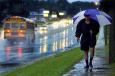
 Forecasters say up to 2 inches of rain is anticipated in some locations. Because of the amount of rain expected to fall, the National Weather service has issued a flood watch for our area until 6 a.m. Tuesday.
Though the steady rain is not with us right now, there are some showers around and heavier rainfall off to the northeast.
A flood watch in effect until tomorrow morning with heavy rainfall amounts. Between 1 and 2 inches are possible.
As we head into the afternoon there could be some thunderstorms, too.
We'll see temperatures rise today. We'll be warming into the 50s this afternoon and getting even warmer tomorrow.
So expect heavy rainfall at noontime today and the potential more heavy showers continuing through this afternoon and into the early evening hours.
After 6:00 p.m. it starts to taper off a bit. Showers become more scattered. And the threat of showers stays with us overnight.
Tomorrow morning we'll see some breaks of sunshine and then skies become partly sunny tomorrow afternoon. Then the nice weather arrives finally with highs in the 60s for Wednesday and Thursday.
advertisement

Author: Copyright 2005 by NBC10.com. All rights reserved. This material may not be published, broadcast, rewritten or redistributed.
Archives
Advertise with SouthJersey.com
Shawnee High School
Attractions: N. Pemberton RR Station
New and Improved
Color Me Happy
Collingswood High School
Don't Miss Your Chance to Enter
Kick Off Summer with Unlocking of Ocean
Prof Tells How to Communicate With Kids
And Then There Were Two
New Certificate Prog. at Rutgers-Camden
The Blue Comet Rides Again
R-C Selected as NJ The Big Read Site
Cleopatra Lecture Series at CCC
Surflight Theatre Earns Innovator Award
More...